
 Herøysund
Vuku
Medby
Eresfjord
Hellevik
Løken
Kjøllefjord
Lalm
Bardu Municipality
Herøysund
Vuku
Medby
Eresfjord
Hellevik
Løken
Kjøllefjord
Lalm
Bardu Municipality
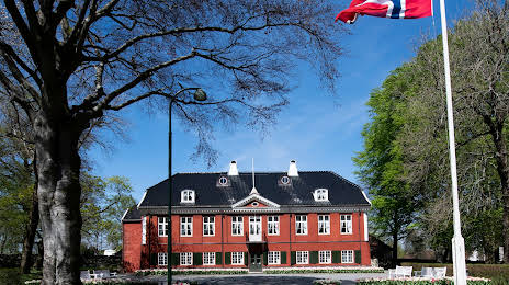
Ledaal on the map, Stavanger, Norway
Photo
Where is located Ledaal
Ledaal — local attraction, which is located at Eiganesveien 45, 4009 Stavanger, Norway and belongs to the category — museum. Average visitor rating for this place — 4.3 (according to 106 ratings, information from open sources and relevant for 2022).
Exact location — Ledaal, marked on the map with a red marker.
You can get directions to Ledaal on the map from your location.
What else is interesting in Stavanger? You can see all the sights if you go to the city page.
Coordinates
Ledaal, Norway coordinates in decimal format: latitude — 58.96693956410382, longitude — 5.718429408291874. When converted to degrees, minutes, seconds Ledaal has the following coordinates: 58°58′0.98 north latitude and 5°43′6.35 east longitude.
Nearby cities
The largest cities that are located nearby:
- Bergen — 159 km
- Aalborg
 (Denmark) — 330 km
 - Aarhus (Denmark) — 415 km
- Odense (Denmark) — 491 km
- Trondheim — 544 km
- Copenhagen (Denmark) — 561 km
- Kiel
 (Germany) — 587 km
 - Malmö
 (Sweden) — 587 km
 - Västerås (Sweden) — 609 km
- Bremerhaven (Germany) — 629 km
- Sunderland
 (United Kingdom) — 638 km
 - Groningen
 (Netherlands) — 638 km
 - Edinburgh (United Kingdom) — 645 km
- Uppsala (Sweden) — 668 km
- Rostock (Germany) — 679 km
- Bremen (Germany) — 682 km
- Emmen (Netherlands) — 688 km
- Stockholm (Sweden) — 697 km
- Glasgow (United Kingdom) — 708 km
Distance to the capital
Distance to the capital (Oslo) is about — 303 km.