
 Mikhaylovka
Dyrestuy
Mikhaylovka
Mayskiy
Novobessergenevka
Tersky District
Lesnoy
Tertezh
Kuz'minskiye Otverzhki
Mikhaylovka
Dyrestuy
Mikhaylovka
Mayskiy
Novobessergenevka
Tersky District
Lesnoy
Tertezh
Kuz'minskiye Otverzhki
Ozero Kurtuguz on the map, Bogdanovich, Russian Federation
Photo
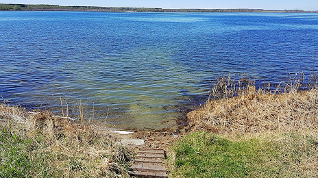
Where is located Ozero Kurtuguz
Ozero Kurtuguz — local attraction, which is located at 169 m and belongs to the category — -. Average visitor rating for this place — 4.9 (according to 9 ratings, information from open sources and relevant for 2022).
Exact location — Ozero Kurtuguz, marked on the map with a red marker.
You can get directions to Ozero Kurtuguz on the map from your location.
What else is interesting in Bogdanovich? You can see all the sights if you go to the city page.
Coordinates
Ozero Kurtuguz, Russian Federation coordinates in decimal format: latitude — 56.830485560574864, longitude — 61.931280175100355. When converted to degrees, minutes, seconds Ozero Kurtuguz has the following coordinates: 56°49′49.75 north latitude and 61°55′52.61 east longitude.
Nearby cities
The largest cities that are located nearby:
- Yekaterinburg — 88 km
- Pervouralsk — 128 km
- Chelyabinsk — 182 km
- Tyumen — 213 km
- Miass — 232 km
- Zlatoust — 233 km
- Kurgan — 252 km
- Perm — 362 km
- Kostanay
 (Kazakhstan) — 407 km
 - Berezniki — 416 km
- Magnitogorsk — 423 km
- Solikamsk — 434 km
- Ufa — 449 km
- Neftekamsk — 485 km
- Sarapul — 505 km
- Sterlitamak — 530 km
- Izhevsk — 537 km
- Salavat — 552 km
- Glazov — 568 km
Distance to the capital
Distance to the capital (Moscow) is about — 1498 km.