
 Mikhaylovka
Dyrestuy
Mikhaylovka
Mayskiy
Novobessergenevka
Tersky District
Lesnoy
Tertezh
Kuz'minskiye Otverzhki
Mikhaylovka
Dyrestuy
Mikhaylovka
Mayskiy
Novobessergenevka
Tersky District
Lesnoy
Tertezh
Kuz'minskiye Otverzhki
Kolonnada on the map, Kislovodsk, Russian Federation
Photo
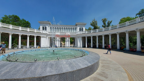
Where is located Kolonnada
Kolonnada — local attraction, which is located at Kislovodsk, Stavropol Krai, 357744 and belongs to the category — tourist attraction. Average visitor rating for this place — 4.8 (according to 3832 ratings, information from open sources and relevant for 2022).
Exact location — Kolonnada, marked on the map with a red marker.
You can get directions to Kolonnada on the map from your location.
What else is interesting in Kislovodsk? You can see all the sights if you go to the city page.
Coordinates
Kolonnada, Russian Federation coordinates in decimal format: latitude — 43.89987352567119, longitude — 42.71672159787243. When converted to degrees, minutes, seconds Kolonnada has the following coordinates: 43°53′59.54 north latitude and 42°43′0.2 east longitude.
Nearby cities
The largest cities that are located nearby:
- Pyatigorsk — 30 km
- Cherkessk — 62 km
- Nalchik — 87 km
- Nevinnomyssk — 100 km
- Stavropol — 138 km
- Nazran — 182 km
- Kutaisi
 (Georgia) — 184 km
 - Vladikavkaz — 185 km
- Maykop — 221 km
- Sochi — 243 km
- Batumi (Georgia) — 267 km
- Elista — 291 km
- Tbilisi (Georgia) — 297 km
- Krasnodar — 318 km
- Khasavyurt — 320 km
- Gyumri
 (Armenia) — 358 km
 - Vanadzor (Armenia) — 375 km
- Volgodonsk — 399 km
- Novorossiysk — 400 km
Distance to the capital
Distance to the capital (Moscow) is about — 1368 km.