
 Mikhaylovka
Dyrestuy
Mikhaylovka
Mayskiy
Novobessergenevka
Tersky District
Lesnoy
Tertezh
Kuz'minskiye Otverzhki
Mikhaylovka
Dyrestuy
Mikhaylovka
Mayskiy
Novobessergenevka
Tersky District
Lesnoy
Tertezh
Kuz'minskiye Otverzhki
Nizhnekamsk Municipal Complex Museum on the map, Nizhnekamsk, Russian Federation
Photo
Where is located Nizhnekamsk Municipal Complex Museum
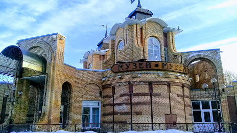
Nizhnekamsk Municipal Complex Museum — local attraction, which is located at Prospekt Stroiteley, 14, Nizhnekamsk, Republic of Tatarstan, 423586 and belongs to the category — museum. Average visitor rating for this place — 4.5 (according to 116 ratings, information from open sources and relevant for 2022).
Exact location — Nizhnekamsk Municipal Complex Museum, marked on the map with a red marker.
You can get directions to Nizhnekamsk Municipal Complex Museum on the map from your location.
What else is interesting in Nizhnekamsk? You can see all the sights if you go to the city page.
Coordinates
Nizhnekamsk Municipal Complex Museum, Russian Federation coordinates in decimal format: latitude — 55.63046809688305, longitude — 51.818169498292235. When converted to degrees, minutes, seconds Nizhnekamsk Municipal Complex Museum has the following coordinates: 55°37′49.69 north latitude and 51°49′5.41 east longitude.
Nearby cities
The largest cities that are located nearby:
- Almetyevsk — 88 km
- Sarapul — 152 km
- Izhevsk — 156 km
- Neftekamsk — 161 km
- Kazan — 168 km
- Zelenodolsk — 206 km
- Dimitrovgrad — 213 km
- Yoshkar-Ola — 264 km
- Ulyanovsk — 266 km
- Novocheboksarsk — 271 km
- Glazov — 281 km
- Tolyatti — 283 km
- Ufa — 283 km
- Cheboksary — 288 km
- Samara — 291 km
- Novokuybyshevsk — 307 km
- Sterlitamak — 350 km
- Kirov — 351 km
- Syzran — 352 km
Distance to the capital
Distance to the capital (Moscow) is about — 889 km.