
 Mikhaylovka
Dyrestuy
Mikhaylovka
Mayskiy
Novobessergenevka
Tersky District
Lesnoy
Tertezh
Kuz'minskiye Otverzhki
Mikhaylovka
Dyrestuy
Mikhaylovka
Mayskiy
Novobessergenevka
Tersky District
Lesnoy
Tertezh
Kuz'minskiye Otverzhki
Khram Rozhdestva Presvyatoy Bogoroditsy on the map, Vladikavkaz, Russian Federation
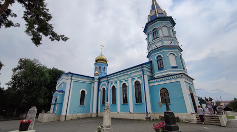
Photo
Where is located Khram Rozhdestva Presvyatoy Bogoroditsy
Khram Rozhdestva Presvyatoy Bogoroditsy — local attraction, which is located at ул.Рождественская, 20, Владикавказ, Северная Осетия - Алания Републиц, Vladikavkaz, North Ossetia–Alania Republic, 362007 and belongs to the category — shrine. Average visitor rating for this place — 4.9 (according to 29 ratings, information from open sources and relevant for 2022).
Exact location — Khram Rozhdestva Presvyatoy Bogoroditsy, marked on the map with a red marker.
You can get directions to Khram Rozhdestva Presvyatoy Bogoroditsy on the map from your location.
What else is interesting in Vladikavkaz? You can see all the sights if you go to the city page.
Coordinates
Khram Rozhdestva Presvyatoy Bogoroditsy, Russian Federation coordinates in decimal format: latitude — 43.020079313637986, longitude — 44.68600899800228. When converted to degrees, minutes, seconds Khram Rozhdestva Presvyatoy Bogoroditsy has the following coordinates: 43°1′12.29 north latitude and 44°41′9.63 east longitude.
Nearby cities
The largest cities that are located nearby:
- Nazran — 24 km
- Nalchik — 98 km
- Tbilisi
 (Georgia) — 144 km
 - Khasavyurt — 158 km
- Pyatigorsk — 171 km
- Kutaisi (Georgia) — 181 km
- Kislovodsk — 183 km
- Makhachkala — 231 km
- Vanadzor
 (Armenia) — 245 km
 - Cherkessk — 245 km
- Gyumri (Armenia) — 255 km
- Nevinnomyssk — 279 km
- Batumi (Georgia) — 292 km
- Stavropol — 306 km
- Yerevan (Armenia) — 313 km
- Derbent — 318 km
- Elista — 366 km
- Sochi — 400 km
- Maykop — 400 km
Distance to the capital
Distance to the capital (Moscow) is about — 1504 km.