
 Mikhaylovka
Dyrestuy
Mikhaylovka
Mayskiy
Novobessergenevka
Tersky District
Lesnoy
Tertezh
Kuz'minskiye Otverzhki
Mikhaylovka
Dyrestuy
Mikhaylovka
Mayskiy
Novobessergenevka
Tersky District
Lesnoy
Tertezh
Kuz'minskiye Otverzhki
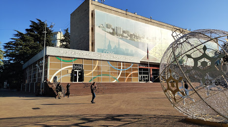
Museum of the History of the resort city of Sochi on the map, Sochi, Russian Federation
Photo
Where is located Museum of the History of the resort city of Sochi
Museum of the History of the resort city of Sochi — local attraction, which is located at Ulitsa Sovetskaya, 26А, Sochi, Krasnodar Krai, 354000 and belongs to the category — museum. Average visitor rating for this place — 4.7 (according to 128 ratings, information from open sources and relevant for 2022).
Exact location — Museum of the History of the resort city of Sochi, marked on the map with a red marker.
You can get directions to Museum of the History of the resort city of Sochi on the map from your location.
What else is interesting in Sochi? You can see all the sights if you go to the city page.
Coordinates
Museum of the History of the resort city of Sochi, Russian Federation coordinates in decimal format: latitude — 43.58629470473032, longitude — 39.72292159802044. When converted to degrees, minutes, seconds Museum of the History of the resort city of Sochi has the following coordinates: 43°35′10.66 north latitude and 39°43′22.52 east longitude.
Nearby cities
The largest cities that are located nearby:
- Maykop — 116 km
- Krasnodar — 171 km
- Cherkessk — 197 km
- Novorossiysk — 199 km
- Nevinnomyssk — 209 km
- Stavropol — 240 km
- Kislovodsk — 241 km
- Batumi
 (Georgia) — 267 km
 - Pyatigorsk — 270 km
- Kutaisi (Georgia) — 285 km
- Trabzon
 (Turkey) — 286 km
 - Nalchik — 313 km
- Kerch — 320 km
- Ordu (Turkey) — 326 km
- Samsun (Turkey) — 379 km
- Bataysk — 393 km
- Vladikavkaz — 403 km
- Taganrog — 406 km
- Nazran — 409 km
Distance to the capital
Distance to the capital (Moscow) is about — 1362 km.