
 Mikhaylovka
Dyrestuy
Mikhaylovka
Mayskiy
Novobessergenevka
Tersky District
Lesnoy
Tertezh
Kuz'minskiye Otverzhki
Mikhaylovka
Dyrestuy
Mikhaylovka
Mayskiy
Novobessergenevka
Tersky District
Lesnoy
Tertezh
Kuz'minskiye Otverzhki
Tyumenskiy Gosudarstvennyy Tsirk on the map, Tyumen, Russian Federation
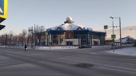
Photo
Where is located Tyumenskiy Gosudarstvennyy Tsirk
Tyumenskiy Gosudarstvennyy Tsirk — local attraction, which is located at Ulitsa Pervomayskaya, 15, Tyumen, Tyumen Oblast, 625000 and belongs to the category — circus. Average visitor rating for this place — 4.7 (according to 1056 ratings, information from open sources and relevant for 2022).
Exact location — Tyumenskiy Gosudarstvennyy Tsirk, marked on the map with a red marker.
You can get directions to Tyumenskiy Gosudarstvennyy Tsirk on the map from your location.
What else is interesting in Tyumen? You can see all the sights if you go to the city page.
Coordinates
Tyumenskiy Gosudarstvennyy Tsirk, Russian Federation coordinates in decimal format: latitude — 57.15228703725446, longitude — 65.53442489851028. When converted to degrees, minutes, seconds Tyumenskiy Gosudarstvennyy Tsirk has the following coordinates: 57°9′8.23 north latitude and 65°32′3.93 east longitude.
Nearby cities
The largest cities that are located nearby:
- Kurgan — 188 km
- Yekaterinburg — 300 km
- Pervouralsk — 338 km
- Chelyabinsk — 340 km
- Miass — 419 km
- Zlatoust — 431 km
- Kostanay
 (Kazakhstan) — 453 km
 - Kokshetau (Kazakhstan) — 498 km
- Perm — 547 km
- Berezniki — 551 km
- Omsk — 553 km
- Solikamsk — 562 km
- Nefteyugansk — 576 km
- Magnitogorsk — 597 km
- Surgut — 617 km
- Ufa — 666 km
- Neftekamsk — 703 km
- Sarapul — 720 km
- Nizhnevartovsk — 725 km
Distance to the capital
Distance to the capital (Moscow) is about — 1711 km.